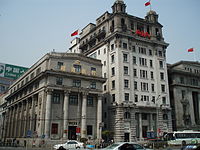
The Shanghai Bund has dozens of historical buildings, lining the Huangpu River, that once housed numerous banks and trading houses from Britain, France, the U.S., Russia, Germany, Japan, The Netherlands and Belgium, as well as the consulates of Russia and Britain, a newspaper, the Shanghai Club and the Masonic Club. The Bund lies north of the old, walled city of Shanghai. This was initially a British settlement; later the British and American settlements were combined in the International Settlement. A building boom at the end of 19th century and beginning of 20th century led to the Bund becoming a major financial hub of East Asia. The former French Bund, east of the walled city was formerly more a working harbourside.
By the 1940s the Bund housed the headquarters of many, if not most, of the major financial institutions operating in China, including the "big four" national banks in the Republic of China era. However, with the Communist victory in the Chinese civil war, many of the financial institutions were moved out gradually in the 1950s, and the hotels and clubs closed or converted to other uses. The statues of colonial figures and foreign worthies which had dotted the riverside were also removed.
In the late 1970s and early 1980s, with the thawing of economic policy in the People's Republic of China, buildings on the Bund were gradually returned to their former uses. Government institutions were moved out in favour of financial institutions, while hotels resumed trading as such. Also during this period, a series of floods caused by typhoons motivated the municipal government to construct a tall levee along the riverfront, with the result that the embankment now stands some 10 metres higher than street level. This has dramatically changed the streetscape of the Bund. In the 1990s, Zhongshan Road (named after Sun Yat-sen), the road on which the Bund is centred, was widened to ten lanes. As a result, most of the parkland which had existed along the road disappeared. Also in this period, the ferry wharves connecting the Bund and Pudong, which had served the area's original purpose, were removed. A number of pleasure cruises still operate from some nearby wharves.
In the 1990s the Shanghai government attempted to promote an extended concept of the Bund to boost tourism and land value in nearby values, as well as to reconcile the promotion of "colonial relics" with the Socialist ideology. In its expanded form, the term "Bund" (as "New Bund" or "Northern Bund") was used to refer to areas south of the Yan'an Road, and a stretch of riverfront north of the Suzhou River (Zhabei). Such use of the term, however, remains rare outside of the tourism literature.
From 2008, a major reconfiguration of traffic flow along the Bund was be carried out. The first stage of the plan involved the southern end of the Bund, and saw the demolition of a section of the Yan'an Road elevated expressway, which will remove the large elevated expressway exit structure which formerly dominated the confluence of Yan'an Road and the Bund. The second stage, begun on 1 March 2008, involves the complete restoration of the century-old Waibaidu Bridge at the northern end of the Bund. The restoration is expected to be completed by early 2009. The next stage of the plan involves a reconstruction of the Bund roadway. The current 8-lane roadway will be rebuilt as in two levels, with four lanes on each level. This will allow part of the Bund road space to be restored to its former use as parkland and marginal lawns. The new concrete bridge that was built in 1991 to relieve traffic on Waibaidu Bridge will also be rendered obsolete by the new double-levelled roadway, and will be demolished.
The redeveloped Bund was re-opened to the public on Sunday 28 March 2010.
Layout
The Bund stretches one mile along the bank of the Huangpu River. Traditionally, the Bund begins at Yan'an Road (formerly Edward VII Avenue) in the south and ends at Waibaidu Bridge (formerly Garden Bridge) in the north, which crosses Suzhou Creek.
The Bund centres on a stretch of the Zhongshan Road, named after Sun Yat-sen. Zhongshan Road is a largely circular road which formed the traditional conceptual boundary of Shanghai city "proper". To the west of this stretch of the road stands some 52 buildings of various Western classical and modern styles which is the main feature of the Bund (see Architecture and buildings below). To the east of the road was formerly a stretch of parkland culminating at Huangpu Park. (This park is the site of the infamous sign reported to have proclaimed "no dogs or Chinese", although this exact wording never existed. Further information, including an image of the sign, can be found at the article on Huangpu Park.) This area is now much reduced due to the expansion of Zhongshan Road. Further east is a tall levee, constructed in the 1990s to ward off flood waters. The construction of this high wall has dramatically changed the appearance of the Bund.
Near the Nanjing Road intersection stands what is currently the only bronze statue along the Bund. It is a statue of Chen Yi, the first Communist mayor of Shanghai. At the northern end of The Bund, along the riverfront, is Huangpu Park, in which is situated the Monument to the People's Heroes - a tall, abstract concrete tower which is a memorial for the those who died during the revolutionary struggle of Shanghai dating back to the Opium Wars.
Architecture and buildings
Some views from the Bund
|
From left to right: The Peace Hotel, Bank of China building, and former Yokohama Species Bank. |
|||
From:http://en.wikipedia.org/wiki/The_Bund
Address: ROOM 103, No 10 Ti Yu Guan Rd, Chongwen District, Beijing
copyright@2010北京百达旅游有限公司


